
Reducing land take is a fundamental cornerstone of the EU environmental policy. Land take can be defined as “an increase in settlement areas over time. This process includes the development of scattered settlements in rural areas, the expansion of urban areas around an urban nucleus (including urban sprawl), and the conversion of land within an urban area (densification). Depending on local circumstances, a greater or smaller part of the land take will result in actual soil sealing” (EC 2012: 40). In other words, land take is a broader concept than additional construction or soil sealing, and includes agricultural constructions, roads, and land uses with little or no constructions such as gardens, parks, and recreational facilities.1 Outside the EU, the equivalent concept of land consumption is more commonly used (Peroni/Pappalardo/Facchinelli et al. 2022).
The issue of land take is topical across Europe, as land take puts pressure on the biophysical capacity of land and soil needed for food production, biodiversity, and ecosystem services (Foley/De Fries/Asner et al. 2005; Eglin/Ciais/Piao 2010). According to European measurements, land take in the EU increased by 597 km2 per year and soil sealing by 245 km2 per year between 2012 and 2018, most often due to conversion of agricultural land use, i.e. arable lands, pastures, and mosaic farmlands (78 % of the land taken).2 Although some land was recultivated or rewilded, the pace of land take exceeded 11 times that of land restoration in the EU in this period. Moreover, since the mid-1950s, land take has been increasing much faster (+78 %) than population growth (+33 %) (EEA 2006: 11). In other words, land take is not only driven by population growth (Colsaet/Laurans/Levrel 2018) but equally determined by welfare growth and governmental management of spatial development (Decoville/Schneider 2016). The settlement area therefore varies widely among different European member states, ranging between 1 % in Spain and 29 % in Malta.3 In particular, the Low Countries (the Netherlands, Luxembourg, and Belgium) have a notably higher settlement area than the EU-27 average of 6 % (respectively 10 %, 15 %, and 21 % according to the Corine Land Cover Map 2018). National measurements have shown that the actual land take is often much higher than the low-resolution Corine Land Cover (CLC) measurement shows (Decoville/Schneider 2016; Colsaet/Laurans/Levrel 2018; Marquard/Bartke/Gifreu i Font et al. 2020; Botticini/Auzins/Lacoere et al. 2022).
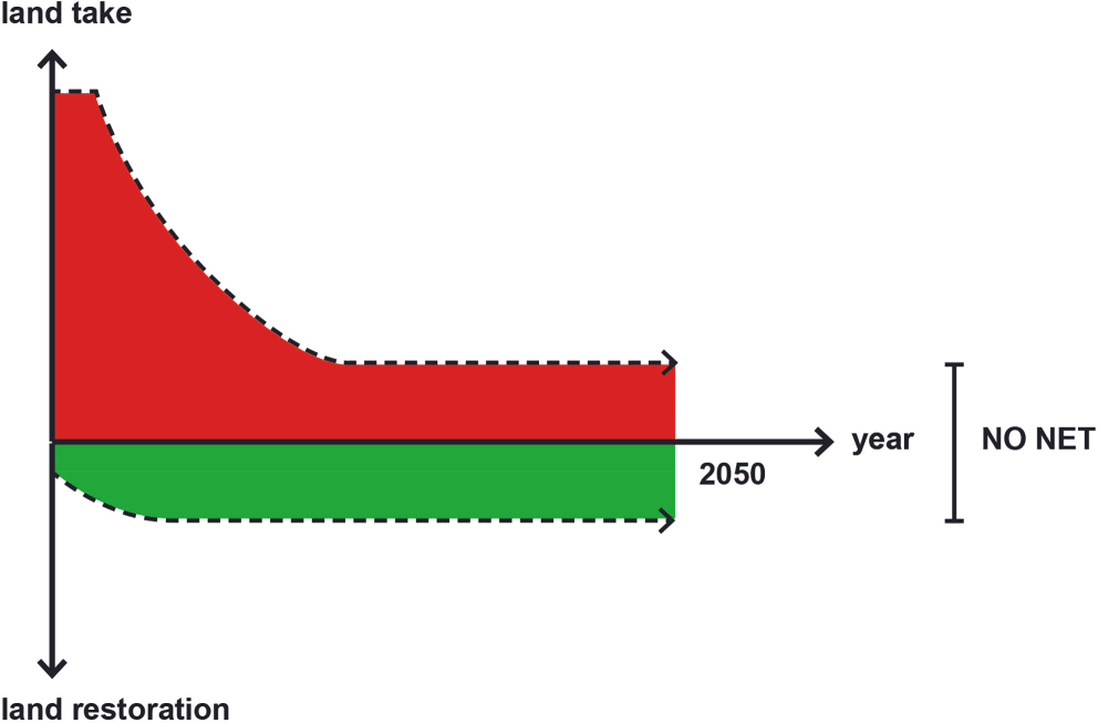
The European Commission calls for the gradual reduction of land take to the point of no net land take by 2050 (EC 2011). Moreover, the EU has put forward a Soil Strategy for 2030 stating that each member state should define an intermediate target by 2030 for land take reduction (EC 2021). No net land take is in fact the land component of the basic environmental principle of No Net Loss (NNL) for ecosystems (Maron/Brownlie/Bull et al. 2018). A no net land take policy aims to reduce land take and enhance land restoration until a net zero state is achieved. This steady state of the settlement area can also be referred to as land neutrality, the quantitative part of Land Degradation Neutrality, as coined by the UN (Orr/Cowie/Castillo Sanchez et al. 2017; Cowie/Orr/Castillo Sanchez et al. 2018). Since the EU has no spatial planning competences, the common no net land take goal has to be implemented nationally – or regionally – across the 27 member states. However, the national implementation of a no net land take policy has far-reaching implications for national spatial planning strategies, which are often traditionally focused on growth and development. The transformation of the existing land policy into a coherent no net land take policy is a significant paradigm shift from unlimited growth (Owens/Cowell 2002) to boundaries. And, in a later phase, a net gain condition could be reached through more re-cultivation and rewilding of land.
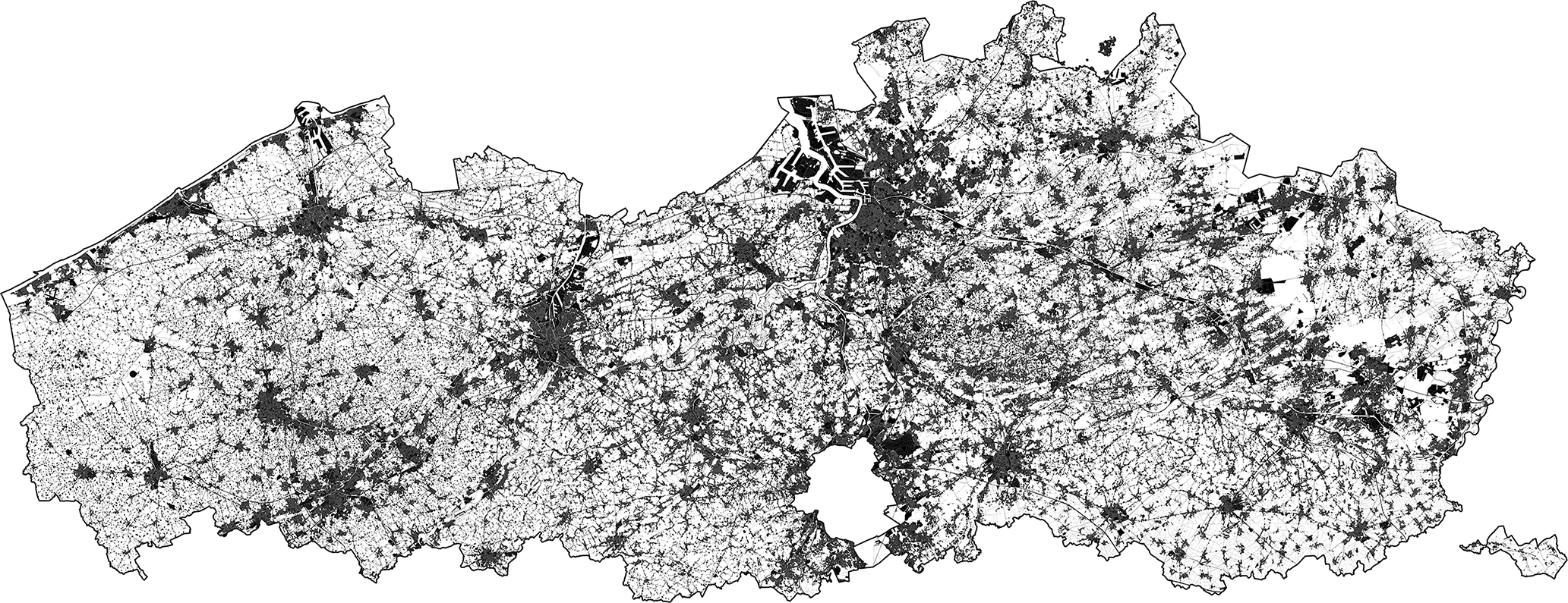
The Flemish region has enjoyed autonomous competence in terms of planning policy for more than four decades. The vast amount of urban sprawl and high land consumption within this densely populated region is now reaching its limits (Buitelaar/Leinfelder 2020). The dominant laissez-faire attitude toward growth has resulted in spatial conflicts, low natural and environmental performance, and high societal costs (Vermeiren/Crols/Uljee et al. 2022). In order to turn the tide, the regional Flemish government announced a no net land take objective in 2016 (Departement Ruimte Vlaanderen 2016). The gradual reduction of daily land take from 5 ha/day currently to 0 ha/day by 2040 has since been set as a priority for the region. However, political and practical implementation is still pending. To argue that the introduction of no net land take policy is a challenge for this region is therefore an understatement. If policy change could work in the Flemish region, it certainly might offer ‘leads’ for other European regions and countries with a similar rate of land consumption.
The structure of the paper is as follows. In Section 2, we first delve into the policy cycle to design and implement a no net land take policy. In Sections 3 to 7, we use the conceptual model of the policy cycle to structure the introduction of a no net land take policy for the Flemish region. We start from the problem setting of the current planning system and the resulting land use (Section 3) and then move to the agenda setting of a new land policy and consider how the topic appeared on the political agenda (Section 4). The subsequent stages of the policy cycle (strategy, implementation, and monitoring; Sections 5 to 7) are outlined on the basis of the advisory report of the Taskforce Bouwshift (Lacoere/Tindemans/Bouckaert et al. 2021), as presented to the regional minister. Some general observations are presented in the discussion section (Section 8) and the paper concludes with some lessons learned from the Flemish case that could be useful for other European member states (Section 9).
The introduction of the no net land take objective is so fundamental that it requires a transformation of the national/regional land policy. Hengstermann and Gerber (2015: 245) define (active) land policy as “all public decisions and actions aiming to implement politically defined spatial development objectives through changes in the use, distribution and value of land”. The paradigm shift from traditional land-use planning to a broader land policy approach stems, according to Gerber, Hengstermann and Viallon (2018: 9), from the “resourcial turn” in planning. Given the fact that land is a limited natural resource, land-use planning needs to allocate and distribute the use of land to minimise conflicts. Even though many instruments from land-use planning are part of land policy, other types of instruments also play a role (i.e. legal, geo-IT, financial-fiscal instruments). Gerber, Hengstermann and Viallon (2018) put a strong emphasis on the interaction between property rights and land use, but the goals and regulations from environmental policy also have a growing impact on land-use planning and are thus becoming an inherent part of a more integrated land policy. Moreover, the European no net land take target emerges explicitly from environmental policy, rather than planning policy.
Several factors can trigger policy change. Cairney (2020) distinguishes factors such as context change, events, and public opinion, but also policy transfer from one governmental level to another can propel change. The voluntary implementation of the no net land take goal from the EU level to a national or regional body is a clear example of policy change by transfer. But the policy transfer needs to be tailor-made given the different national ratios of land take and the various planning systems that regulate land use (Larsson 2006; OECD 2017).
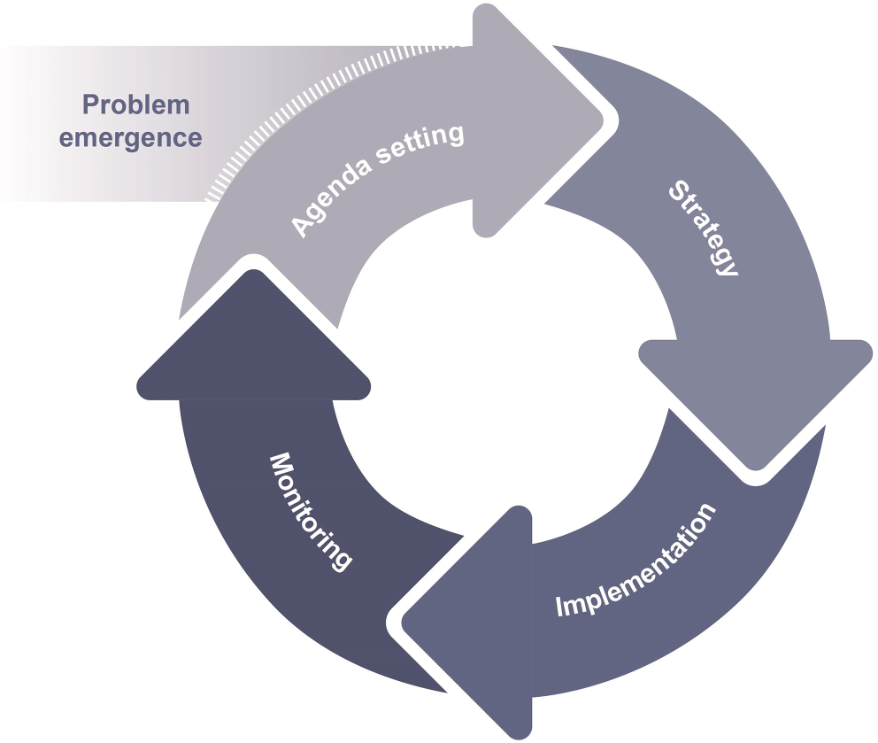
Integrating the no net land take target into the traditional land policy is similar to converting a running engine. Gradually the new land policy needs to be inserted into the existing, operational system. Various models of the sequential and iterative process of policy change exist in the policy research domain. This paper draws on Lasswell’s generic model of policy development as stages of the decision-making process (Lasswell 1956; Lasswell 1971). A common way to break down policymaking into stages is by the generic policy cycle model. In the transition from ‘as is’ to a land policy ‘to be’, five cyclic stages are commonly distinguished: problem definition, agenda setting, strategy, implementation, and evaluation (Jann/Wegrich 2009; Howlett/Giest 2015). Of course, this policy model has its limitations, as it oversimplifies complicated processes or is in many ways unrealistic (Cairney/Zahariadis 2016). But, in all its simplicity, it is an appealing and useful model to outline a new policy, both descriptive and prescriptive (Cairney 2020). Adelle, Jordan and Turnpenny (2012) add a pre-phase of problem emergence at the starting point of the cycle. After all, the problem emergence has a causal relationship with the stage of agenda setting. The stages of agenda setting, policy formulation, and decision-making are often intertwined in practice in a single stage. In contrast, the crucial implementation stage consists of only one stage, even though the bulk of the actual work is done in this phase. At the end of the cycle, the feedback of the monitored results is confronted with initial objectives, making the model iterative. Policy evaluation often leads to the re-conceptualisation of initial policy problems and to the modification of the policy actors’ positions (Howlett/Ramesh/Perl 2009).
| 1. |
Problem emergence arising from changing circumstances and positions, problem definition by analysing the land take ratio and its specific national characteristics, causes, consequences, and risks (What is the current status and why do we need change?).
|
| 2. |
Agenda setting by applying European policy at a national/regional level, formulating policy, setting objectives, and the starting point of new land policy (What change do we need?).
|
| 3. |
Strategic stage by assessing different options, selecting policy instruments, making decisions, and legitimising the no net land take goal (How and when will policy change?).
|
| 4. |
Implementation stage, executing the strategy, providing staff, instruments, and financial means accordingly to appointed organisations (The actual change ‘on the field’ and who will do what?).
|
| 5. |
These five stages are closely interlinked and can flow into each other if the impetus for the next stage can be found in the preceding phase. Also, if one stage is weak and fragile, the cycle might stall during the subsequent stage. How a new no net land take policy can be developed through the five stages of the policy cycle is demonstrated by the following case study of the Flemish region.
The initial stage of problem emergence starts with changing circumstances and/or increasing public awareness about land consumption and its consequences. The problem can be defined by determining whether or not the extent of (net) land take poses a problem for the specific country or region and if it is perceived as a problem (or not) by the public and decision-makers. This requires both a thorough measurement of the actual land take and land restoration and an analysis of how the current land policy stimulates or inhibits land take.
The Flemish planning system has a classic structure consisting of strategic policy plans, binding land-use plans, and operational instruments that can be applied by the regional, provincial, and municipal authorities. At the strategic level, the Spatial Structure Plan for Flanders (Ruimtelijk Structuurplan Vlaanderen) was approved in 1997, but the plan has become outdated. While this strategic plan mentions and recognises the problem of land take, it puts forward only a few specific, non-systemic measures. These measures significantly reduced the daily land take in the short term from 13 ha in 1997 to 6 ha in 2003 (Departement Ruimte Vlaanderen 2018: 36). Binding land-use plans (gewestplannen) define buildable zones (housing, economic development, recreational use, etc.) and non-buildable zones (agriculture, natural areas, forests etc.). However, during the following two decades, the subsequent ministers reintroduced deviation rules for new developments in the agricultural and natural areas in the land-use plans. As a result, the boundaries of the urban areas ‘leak’ and land take continues at the expense of agriculture and nature (i.e. transformations of former farmsteads into residential dwellings with adjacent gardens and hobby farming, and into non-agricultural companies). Furthermore, the oversupply of buildable zones that can be developed according to the land-use plans is left untouched. Because these land-use plans, dating from the 1970s, remain valid until they are replaced by new ones and because governments are reluctant to rezone, the remaining buildable zones are a threat to a vast amount of open space and nature even to this day (Lacoere/Leinfelder 2022). Such rigid – and often outdated – planning systems need more fundamental reforms if they are to support sustainable land use and contribute to climate change policy and other environmental goals such as protecting the natural capital of land. In Flanders, there is no system of expiry in the land-use planning system and, consequently, plans need to be adjusted piece by piece to bring them in line with a no net land take regime. At the operational level, the active land policy is mainly applied to facilitate development and support agricultural intensification. In other words, land policy in Flanders was and, as a consequence, is still not about protecting and managing land for its intrinsic value.
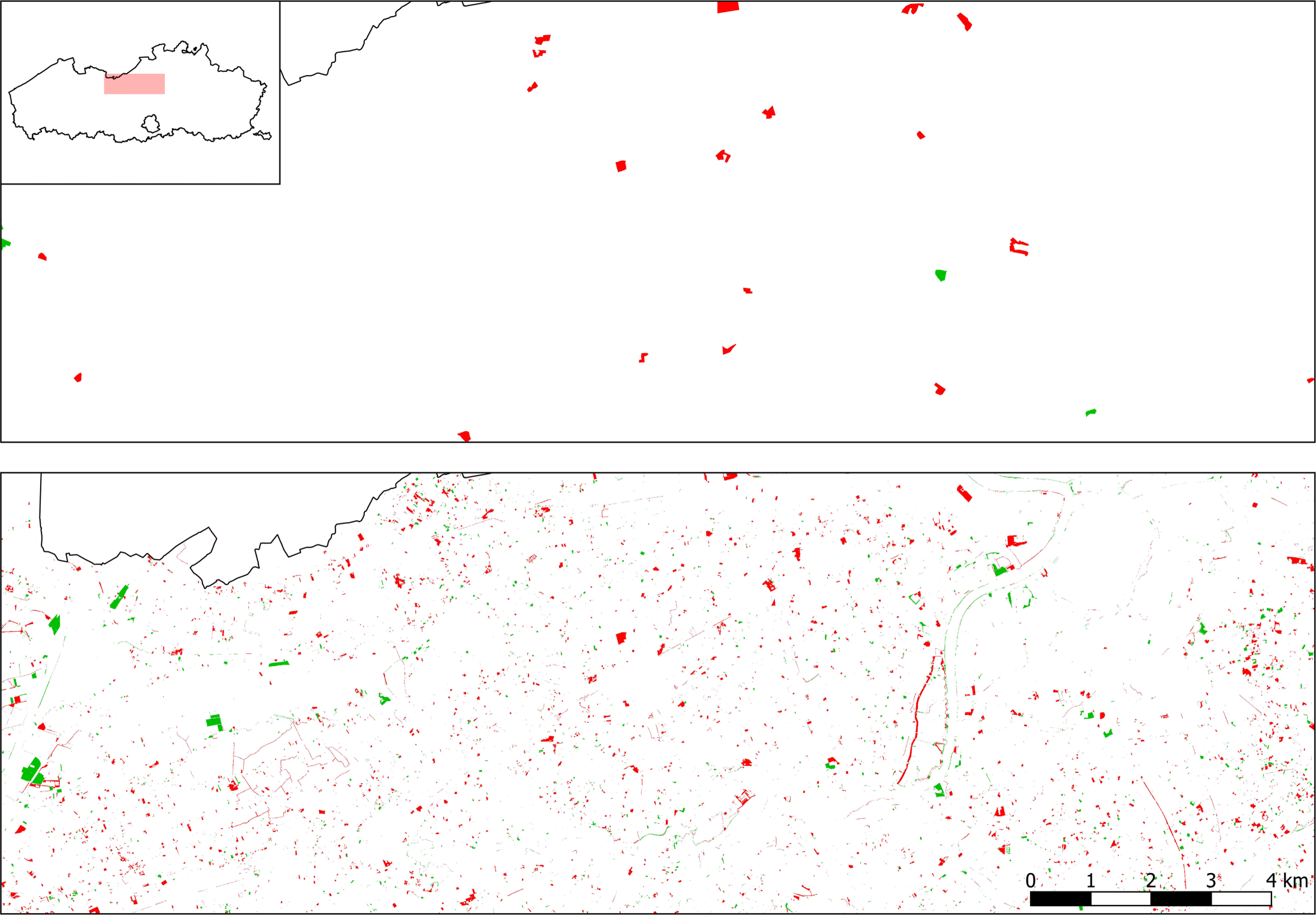
Without new land take reduction measures, land neutrality will not be achieved. The ability to generate and have accurate data for the indicator ‘land take’ is a condicio sine qua non to arrive at a well-founded strategy and an objective debate on land consumption. The European Corine Land Cover measurements (CLC) by the European Environment Agency (EEA) and Copernicus Land Monitoring Service (CLMS) provide national data on land use and land take. But the absolute figures per country from the Corine data appear in many cases to be an underestimation of actual land take (Decoville/Schneider 2016; Barbarosa/Vallecillo/Baranzelli et al. 2017; Botticini/Auzins/Lacoere et al. 2022). The CLC detects only changes larger than 5 ha, and the degree of accuracy also varies widely across EU member states (EEA 2017). This causes a general underestimation of the actual land take, especially in areas with highly dispersed development and low building density (such as Flanders, Luxembourg, Switzerland, Austria and other countries). To improve these GIS measurements, the Copernicus Land Monitoring Service is planning the second generation CLC and CLC+ products for land change/land-use monitoring. Until these new data are available, national/regional GIS measurements of land take and land restoration should be considered, although this may be an expensive intermediate option.
Land take | Land restoration | Net | Pace | |
|---|---|---|---|---|
Corine Land Cover (CLC) 2012-2018 | 2,258 ha (land-use codes 200-900>100) | 956 ha (land-use codes 100>200-900) | 1,309 ha | 0.59 ha/day |
Land-Use Map 2013-2019 | 18,674 ha | 7,604 ha | 11,081 ha | 5.1 ha/day |
As a next step, land take must be differentiated to identify its nature and the relevant drivers. The regional Land-Use Map can be used to determine the type of land change (previous versus new use), geographical locations, and the allocated land-use zone. In absolute numbers, the increase in land take appears to be due to (in order of decreasing importance) economic and industrial developments, transport infrastructure, and residential development. In relative terms, however, the number of agricultural buildings increases the fastest. More than half of the land take occurs in agricultural, non-buildable zones of the land-use maps (2.8 ha/day in the form of dwellings with gardens, transport infrastructure, recreational use, services, etc.). A third of the land take is situated in residential zones, and a little over 10 % in economic development zones. The problem setting of land take – in the case of the Flemish region – should be largely reoriented towards the rural areas.
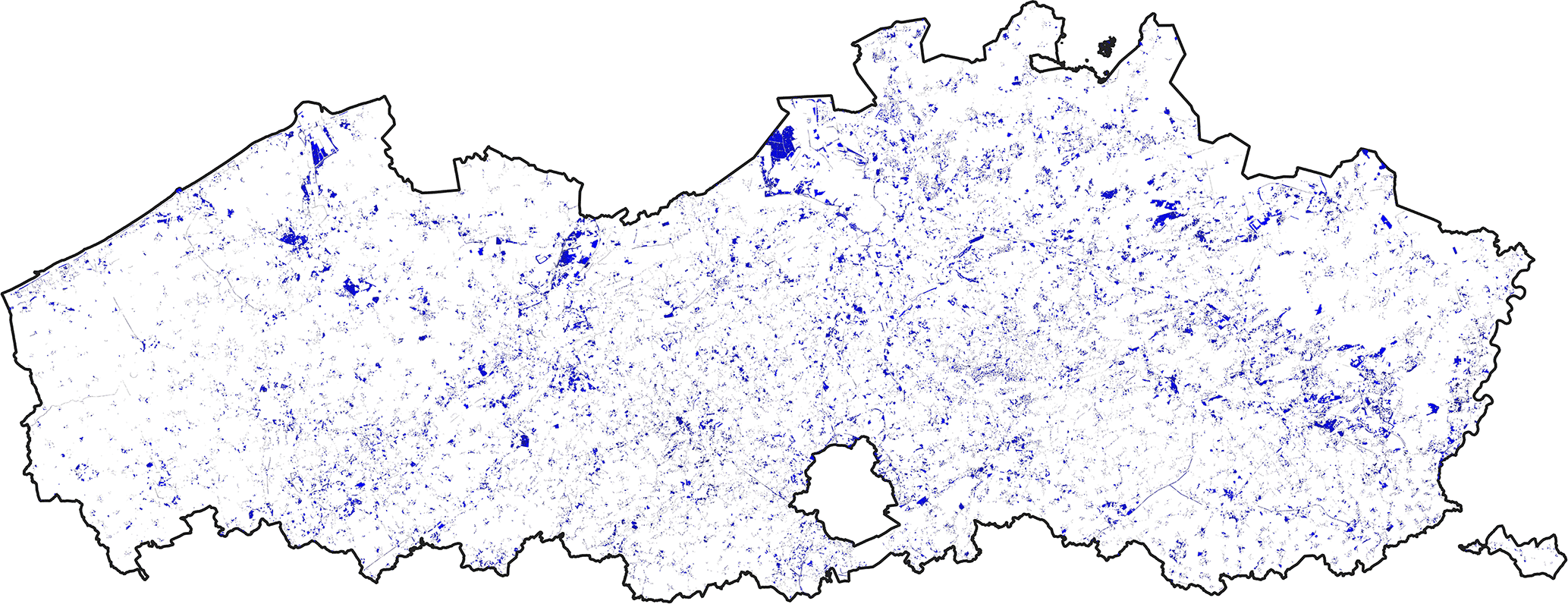
In addition to current land take, it is important to detect and measure how much buildable land is zoned and potentially under pressure in the future, here coined as ‘land take risk’ (LTR). The land take risk within buildable zones is the land still in agricultural use or in a natural state that has been zoned for development. The land take risk within the buildable zones can therefore be estimated by a GIS layover of the buildable zones and the land that is still in agricultural use or in a natural state.
In the stage of agenda setting, raising public awareness and (re-)occurring ecological events increase the pressure in the political forum to initiate policy changes. After acknowledging the land take problem, the competent national/regional authority can, as a first step, issue a statement of intent and announce policy change.
Even though the problems of land take and urban sprawl have been extensively researched and documented, this does not immediately lead to policy changes. In the case of Flanders, a long phase of public debate preceded any such changes. The formal introduction of the no net land take concept (Departement Ruimte Vlaanderen 2016) became a turning point in the conceptualisation of Flanders’ regional planning. For the first time, final limits on land take were considered and widely debated, even in the media. Meanwhile, the Bouwshift or Shift in building attitude, as land neutrality was coined in Flanders, seems widely accepted across political parties, partly due to the massive climate marches in Belgian cities and the efforts of the Flemish Bouwmeester (the Flemish Government Architect) and other experts who kept advocating for change. Flooding incidents and local conflicts concerning deforestation also strengthened the emergence of the no net land take objective on the political agenda.
Once land neutrality is on the political agenda and a political majority is reached about the basic concept, the national/regional authority can decide on the reduction trajectory. Provided there is sufficiently accurate land take data available, the starting point of the trajectory is deduced, and thus the extent to which land consumption must be reduced to achieve no net land take. Next, the government needs to decide on the final point of the reduction trajectory: Should land neutrality be achieved by 2050 or earlier? Furthermore, between the starting and final point, one can opt for either a gradual reduction or a trend trajectory that stops abruptly by 2050. However, the latter scenario can generate double as much land take as the former gradual scenario. With the option of a gradual trajectory, the decision on intermediate milestones is part of the decision-making process. According to the Soil Strategy for 2030, adopted by the European Commission in 2021, each member state has to report its interim 2030 target by 2023. In this way, the EU has already steered towards a national intermediate milestone for 2030.
Although the Flemish Bouwshift was set on the political agenda in 2016, nothing more has been done at the strategic, regulatory, or operational planning levels since. The only formal approval currently consists of the strategic vision for the Spatial Policy Plan Flanders (Strategische Visie – Beleidsplan Ruimte Vlaanderen (BRV); Departement Omgeving 2018) in which only a few pages are devoted to the no net land take concept. The premise is to gradually reduce the land take from 6 ha/day to land neutrality by 2040, with an intermediate milestone of 3 ha/day by 2025. Remarkably, both the starting and final points of the reduction trajectory have changed over the years. The starting point of 6 ha/day – based on new and more accurate measurements – was lowered to a more favourable figure of 5.1 ha/day, and the final point – initially set at the 2050 EU target – was brought forward to 2040 after the Flemish government was criticised for not being ambitious enough. The interim milestone in 2025 was politically reconfirmed (Krokusakkoord in 2022), even though this deadline is approaching and few concrete measures have yet been taken.
Once land neutrality is politically endorsed, the strategic elaboration of this new land policy can be initiated. More specifically, the general no net land take goal needs to be elaborated as a long-term project in terms of an action plan allocating tasks and responsibilities between the different governmental levels, outlining a timeframe with feasible short-term goals, and providing a substantial package of resources and budget. After the agenda setting of the no net land take target, further strategic elaboration in Flanders was paralysed by the political intention of the centre-right government to conditionally link the no net land take goal to higher financial compensation for landowners affected by downzoning (2018-2023). The financial calculation of the compensation scheme was radically revisited by the regional government. This revised scheme is estimated to cause an increase in compensation costs by a factor of 5 to 10 depending on the site conditions (Lacoere/Hengstermann/Jehling et al. 2023: 197). Consequently, the public debate has been focusing more on the political proposal of financial compensation (planschade-vergoeding) than on the strategic goal of no net land take. By making the introduction of the new policy dependent on a key instrument of land policy, the cart was politically put before the horse. Despite the objections from municipalities, environmental organisations and planning experts – and the extensive media coverage that accompanied it – the new compensation scheme was approved in 2023 (Instrumentendecreet). At the same time, residential reserve areas were also blocked by a separate decree (Decreet Woonreservegebieden), although it remains to be seen whether this is a real improvement compared to the current restrictions as the municipalities can unblock these zones again.
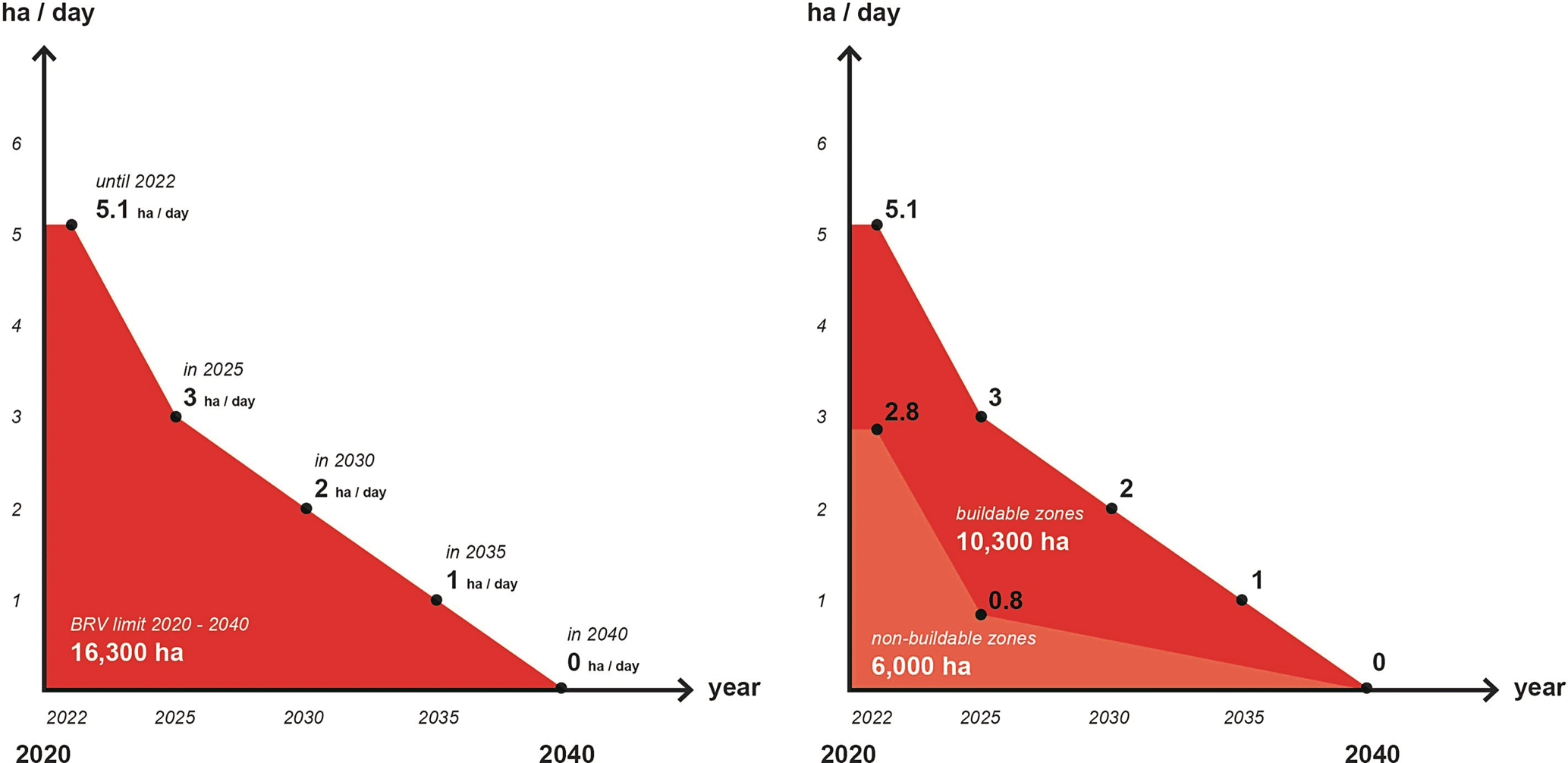
The land take limit was then split up between a sub-trajectory for non-buildable and buildable zones (see Fig. 5 right). In a strategic phase-out, two clear phases can be distinguished: the urgent reduction of land take in the non-buildable agricultural and natural zones in the land-use plans by reducing the deviation and exception rules in legislation (area indicated in salmon, 2022-2025) and subsequently the gradual rolling back of the not-yet-realised buildable zones in the land-use plans (area indicated in red, 2025-2040). Within a capped no net land take regime, these two subgroups act as communicating vessels; the more land take occurs in the agricultural zones due to unrestrictive legislation, the more buildable areas need to be downzoned to contain the total land take to the land take limit. Based on the GIS data, the taskforce suggested reducing the share of land take in the non-buildable zones as a quick win from 2.8 to 0.8 ha/day. As a result, the intermediate milestone of 2025 (3 ha/day) could still be achievable. To determine the land oversupply of buildable zones within the no net land take regime, the difference between the land take risk (part buildable zones, ca. 60,000 ha, Fig. 4) and the land take limit (part buildable zones, ca. 10,300 ha, Fig. 5) needs to be addressed. At least 30,000 ha of the high-risk buildable zones in land-use plans need to be wiped out, while 20,000 ha (for instance for recreational use) could be controlled by more restrictive regulations (Lacoere/Tindemans/Bouckaert et al. 2021: 67). Also, an action plan is proposed to make the reduction trajectory feasible. Sub-phases up to 2040 are identified during which the three governmental levels (the Flemish region, five provinces, and 300 municipalities) can implement a set of measures and instruments. To align the whole process, a board per sub-region might coordinate the actions and monitor the timeline and co-financing by the three planning levels.
During the implementation stage, the strategic preparation is actually executed. This is the critical stage where the policy change is brought ‘to the field’. Whereas the introduction of a no net land take policy in the previous stages only intervenes in the government ‘apparatus’, the implementation stage also interferes with the property and development rights of landowners. The impact on property varies widely according to the land-use instruments used (Gerber/Hartmann/Hengstermann 2018). The specific selection of instruments needs to target the main drivers of land take. Therefore, achieving a long-term goal such as land neutrality requires a wide range of land-use instruments applied in a specific sequence and combination.
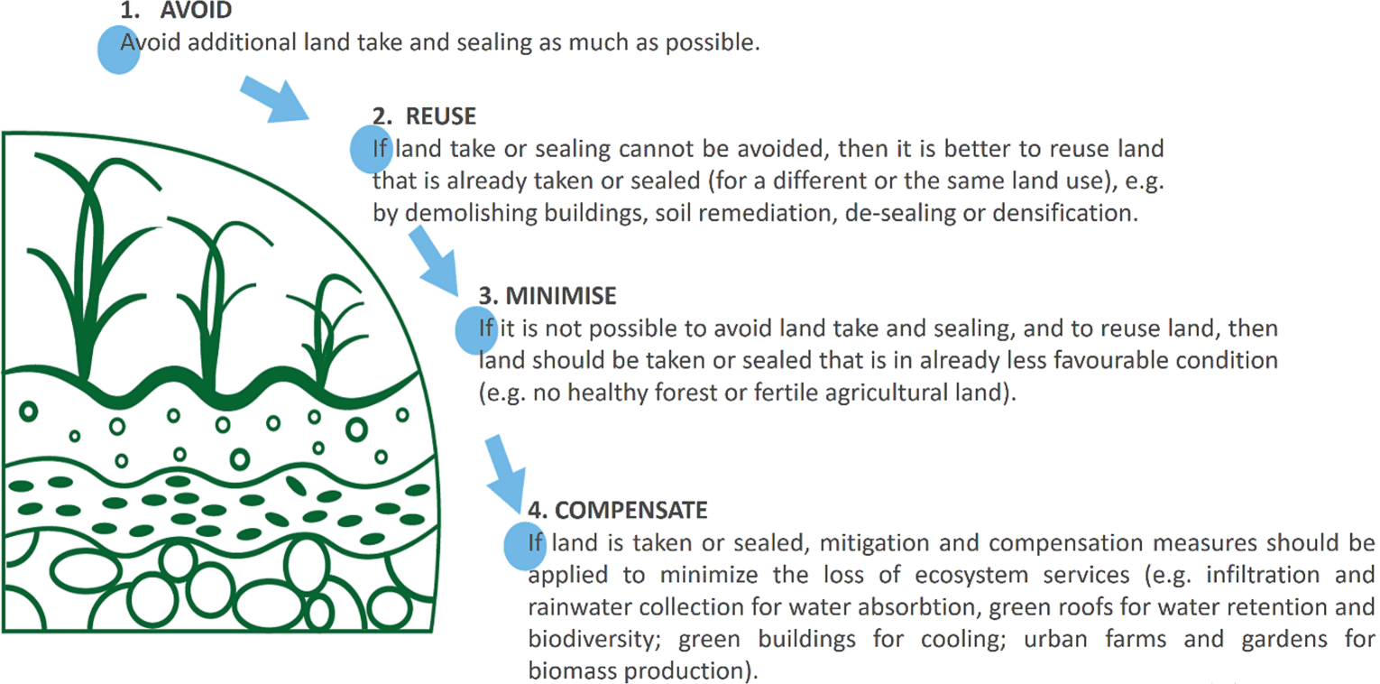
Any land policy instrument – with the potential to reduce land take or increase land restoration – can be positioned on the mitigation ladder from avoiding to compensating. Some instruments are more likely to have a preventing effect, some will have a mitigating effect on land take, while others will foster land restoration. In its advisory report, the Flemish taskforce selected the following land-use instruments in relation to the mitigation hierarchy (2021).
The high land take rate in the non-buildable zones for agriculture and nature in land-use plans is fuelled by planning deviations and exceptions. A quick drop in land take is thus feasible by simply abolishing or radically rolling back these deviation and exception rules by legislative work. This ‘quick-win’ measure can be implemented easily, it simplifies the regulations significantly and it does not cause compensation costs as the existing zoning rules are not changed. It only takes a certain amount of political will and courage to halt the underlying ‘deviation culture’ so deeply rooted in the Flanders’ planning practice.
More work and costs will be involved in preventing land take by downzoning the oversupply of buildable zones in land-use plans. In the period 2016 to 2019, an additional 640 ha was ‘upzoned’. In a first stage, the introduction of the concept of zoning neutrality is required to prevent the sheer amount of zones from increasing. If additional development is permitted through a land-use plan, at least the same amount of buildable zone must be downzoned elsewhere. In other words, in a binding regulatory system of land-use plans, the operation of a no net land take regime starts by applying zoning neutrality or ‘no net zoning’.
The specific designation of land to be downzoned is a next step. If these sites are selected strategically, a downzoning campaign can also entail added value for food, climate, and biodiversity policies. The land with the highest natural value and ecosystem performance (i.e. water retention, carbon sequestration) was filtered from the land take risk data (Fig. 4). A priority of 11,000 ha of natural land – at risk of being lost – was identified (Lacoere/Hurtado/Engelen et al. 2022). A second selection of 19,000 ha of land with either high soil productivity or landscape quality combines with this to make up the 30,000 ha downzoning target. It is disconcerting that the Flemish government has made the no net land take policy dependent on the revision of the compensation scheme (planschade). According to the decision-makers, higher financial compensation is needed ‘to enhance the support of landowners’ for the Bouwshift. The downzoning of 30,000 ha of land take risk is estimated to involve costs of € 6.6 billion in the current compensation scheme, while with the new, unclear scheme this increases to € 19 billion (Viaene/Paelinck/Lacoere et al. 2022: 33).
Downzoning can be conducted strategically by aiming to protect areas of high agricultural or natural value. However, a rezoning programme of at least 30,000 ha could become a long and complex planning and approval process. To implement the more urgent European biodiversity and climate goals by 2030, a precautionary measure could involve freezing all these zones while waiting for final downzoning. As an alternative or complementary measure to downzoning (with its high costs), common instruments of compulsory purchase or expropriation can also be considered, allowing a higher ‘return on investment’ for the public budget than one-directional financial compensation to landowners (Lacoere/Van Hoorick 2020).
Currently, a major share of all new residential entities are built within existing settlement areas. The Flemish Bouwshift implies that the ‘greenfield’ part should also gradually move to already ‘taken’ land, which makes a no net land take land regime for housing less unrealistic or radical than one might think. A double-sided ‘develop and protect’ approach is needed to achieve a gradual transition towards 100 % net land reuse and 0 % net land take on agricultural and natural land.
On the develop side of the land regime, incentives are needed to maximise the reuse of already taken land. However, it is not desirable that the reuse and densification of existing sites should be random. Preferably, they should be situated on sites that are well connected by public transport (Transit Oriented Development) and serviced by nearby facilities. Clear urban boundaries can be useful to distinguish the two-sided no net land take policy for a specific territory. Within the boundary, the local government attracts development and pursues a well-balanced urban fabric, outside the boundary land take is banned and the landscape is restored.
In Flanders, the ‘infill’ potential of reusable land and vacant buildings is large. The building density of new developments on recycled land has doubled over the past two decades. The active mobilisation of this infill capacity is thus of paramount importance in the no net land take land regime in order to ease the pressure on the real estate market and to prevent housing affordability from being compromised through a thrifty land policy. After all, a limited land capacity does not necessarily imply a limited development capacity if the densification and efficient use of the existing settlement structure is well handled.
Special attention needs to be paid to the land take by the economic sectors including the intensive agricultural branch. Pushing this type of development towards 100 % land reuse will be more difficult to achieve than with residential development.
The limitation of construction and soil sealing is insufficient to minimise land take, which is also significantly driven by the establishment of new gardens and recreational infrastructure (such as golf courses, playgrounds, etc.) at the expense of agricultural and natural areas. Therefore, to align the building permit procedures with the no net land take policy, it is necessary to make all types of land and soil conversion subject to a soil change permit requirement and to minimise allowed land reconversions to modest dimensions. At the moment, the withdrawal and conversion of agricultural land to – for example – gardens do not require any approval or a permit in the Flemish region.
To minimise the impact of land take within buildable zones, supplementary restrictive regulations may need to be considered by decision-makers. This technique bypasses radical downzoning and high compensation costs. For example, the approximately 20,000 ha of recreational and park zones of the land take risk can be screened and given restrictive building regulations. Also, development in ribbon residential zones can be tempered by adding limiting prescriptions. Other, more innovative instruments such as land readjustment and tradable development rights are often put forward as adequate solutions, but they only help achieve no net land take if they yield a significant net reduction in zoning. In contrast to the academic attention they receive these instruments remain sub-optimal techniques that minimise rather than avoid land take.
Despite this, there is plenty of compensation potential in the Flemish region. Around half a million buildings are scattered across the Flemish region (Pisman/Vanacker/Willems et al. 2018: 463). The highest priority could be the restoration of river valleys and wetlands, where scattered buildings and sealing are difficult to sustain and costly to maintain in the longer term. Vacant farms and stables, especially those located next to – and in – natural areas, can be purchased and demolished for landscape restoration and rewilding. The third source of spatial compensation can be found in the removal of local roads and other sealed infrastructure that is redundant, estimated to total approximately 10,000 ha (based on Atelier Romain 2021). The compensation mechanism can function as the closure instrument of no net land take, although it is the final and undoubtedly the least effective measure for halting land take.
Finally, the policy cycle is closed by monitoring at regular intervals. Concrete progress towards land neutrality can be assessed by a fixed set of indicators. Basic indicators of a no net land take trajectory include the extent of land take and land restoration (e.g. in ha/day), the original and the new land use (agriculture, natural areas, forest, and waterbodies), the nature or type of land take (built, sealed, non-built) and the zones on the land-use plans in which the land take took place (effectiveness of regulation). Differentiated monitoring allows a deeper analysis and understanding of what drives land consumption and restoration, and of whether the measures and instruments applied during the implementation stage are sufficient and effective enough to achieve the reduction intended. To protect land and nature, the mapping of the original agricultural and natural conditions should be as accurate as possible (see Section 3).
The feedback loop of monitoring and reporting (Kato/Ahern 2008) can be conducted per phase or fixed period of time. For Flanders, this baseline measurement is carried out (Land-Use Map) with a three-year interval. However, these GIS measurements should be improved, especially conserving the mapping of natural areas, forests, and agricultural land use. Also, a more differentiated representation of the type of land take is lacking in the current Flemish measurements. Despite the baseline maps and extensive reporting on the spatial evolution of the Flemish region (Pisman/Vanacker/Willems et al. 2018), the official monitoring can be improved and aligned by a fixed set of indicators.
By going through the stage of monitoring, the policy cycle is closed, and interim decisions can be made to keep the no net land take policy on track, adjust the strategic setup or end the policy altogether. The strategy and implementation may be reconsidered, for example by revising, adding, or removing interim milestones and specific instruments that are not effective and efficient. Once the condition of land neutrality is achieved, the policy focus should shift to controlling the steady state over the long term, or more ambitiously, to managing a ‘net gain’ evolution restoring land for nature and agriculture.
In this paper, we have shown that it is useful to critically consider the introduction of an ambitious objective in land policy, such as no net land take. The stages of the policy cycle provide clear guidance for this purpose. In order for the new land policy to be successful, each phase must be thoroughly outlined and prepared in advance. This applies not only to the implementation of no net land take in Flanders but undoubtedly also to policy changes in other member states that want to meet European land ambitions.
We indicated how, in the preceding problem setting of the policy cycle, there is still a considerable quantitative gap between estimation of current daily land take by the European Corine Land Cover and the Land-Use Map of Flanders. The regional estimate is ten times higher than the European calculation. It is obvious that clarity concerning the actual starting point of the reduction trajectory is crucial. A regional no net land take for Flanders has been announced but is still not part of the legislative framework. Central to Beleidsplan Ruimte Vlaanderen Strategic Policy Plan (2018) are minimise and reuse measures such as densification, multiple land use, reconversion, and temporary use of space. Therefore, the current no net land take discourse is in practice narrowed down to rather obvious development instruments in land policy that support reuse and infill development of already ‘taken’ sites. With its soft and one-sided approach of development incentives, the regional government secures the support of the construction and real estate sector but does not actually implement a new policy of land protection. The more cumbersome and less popular protective instruments that hinder development to conserve land for nature and agriculture are avoided or passed on to the next generation of policymakers and other levels of government. This also explains the renaming of Betonstop by the regional government to Bouwshift. However, Bouwshift wrongly suggests that land neutrality is primarily about building differently rather than protecting and restoring land and soil. Thus, both the terminology and the instruments selected conceal the one-sided ‘pull’ approach of regional politics to the Flemish no net land take policy. Changes in Flemish regulations in recent years have been dominated by increasing building capacity (ruimtelijk rendement) and faster procedures in granting building permits. In addition, the regional government wants to significantly increase the compensation scheme for owners whose property is downzoned; this discourages municipalities from rezoning. Therefore, it can be seen that the regional government is paradoxically reinforcing its traditional growth policy under the pretext of a no net land take policy. We already indicated that the gradual reduction of the daily land take until 2040 implies that a maximum of 16,300 ha of open space can still be taken for development. In other words, both the old Spatial Structure Plan Flanders (RSV) and the new Spatial Policy Plan Flanders (BRV) are based on the premise of spatial growth, albeit on strategically better-located sites and at different gradations of densification. The 1997 Spatial Structure Plan Flanders mainly constituted an adjustment to spatial growth by concentrating new developments through expansions on the outskirts of urban areas and towns. Moreover, it still envisaged 8,500 ha of additional rezoning for economic and recreational purposes. The new Spatial Policy Plan Flanders (2018) announces a paradigm shift from spatial growth to spatial boundaries. For the first time, a temporary freeze and possible reduction of ‘greenfield’ development are politically envisaged.
However, the operational frameworks necessary to implement the no net land take ambition in a coherent way, are still missing. The strategic Spatial Policy Plan Flanders expresses the intention to pursue the reuse of land and minimise land take. But avoiding and compensating land take are also fundamental components of the mitigation approach. This will require a large-scale intervention in the oversupply of buildable land and the abolishment of the deviation rules in legislation for non-agricultural developments in agricultural zones. The three government levels will inevitably have to limit the development options of private landowners, resulting in compensation claims. The new decree to substantially increase the monetary compensation for rezoning clearly undermine the no net land take goal and make it unaffordable for the municipalities and the Flemish government (Lacoere/Hengstermann/Jehling et al. 2023).
With its no net land take ambition, the European Commission underlines the importance of soil for responding to various societal and environmental challenges such as carbon sequestration in the soil, flooding, water shortage management, and (local) self-sufficiency in food production. “The lack of awareness about the role of soil in the ecosystem and the economy as well as about possible negative impacts of land take, especially in the medium to long term and considering the expected effects of climate change, has been identified by many observers as one of the major obstacles to more sustainable land planning policies and land use” (EC 2012: 35).
However, implementing the European no net land take ambition in member states’ planning policies is not as easy as it seems. In most countries a profound paradigm shift in thinking about spatial development is required. Whereas today spatial growth for residential, economic, and other purposes is still paramount, pursuing a no net land take policy implies a more protective reflex towards the soil of the remaining ‘undeveloped’ land. European member states that have historically been careful about granting development rights or have adopted a more protective and flexible planning system will have less difficulty achieving the no net land take target. In contrast, countries and regions, such as the Flanders region, which have been generous in granting land rights and cherish protected property rights, have a planning system that leaves less margin for policy change towards a land-neutral regime (Lacoere/Leinfelder 2022). Furthermore, the regional government has increased financial compensation for downzoning, making it difficult to actually implement the new no net land take policy. In this way, the regional introduction of land neutrality threatens to get bogged down at the agenda-setting stage. Similar to some member states, land take has been so chaotic and far-reaching that the question arises as to whether part of the already built-up fabric should not be returned to open space. Complementary to reforming the planning system, land management involving demolition, de-sealing and land restoration is therefore needed. A project-based approach to ‘reverse’ planning is inherent to a new land regime that aims at net neutrality or net gain for land.
In a balanced no net land take regime, instruments are deployed on both the development and the protective sides of the new land policy. Development instruments should attract and facilitate grey and brownfield developments for 100 % land recycling. In contrast, protective instruments should prevent traditional greenfield developments to 0 % net land take. Obviously, the development of land policy instruments on both sides of the no net land take regime is an important domain for further academic research. In particular, the instruments of protective zoning, rezoning, financial compensation of landowners, and spatial compensation by land restoration are crucial for the no net land take target and may gain importance in planning research. A paradigm shift from growth to final boundaries – and even land restoration – requires a fundamental review of existing regulations and land-use instruments. After all, these were often conceived from a growth mindset. A substantial intervention in the property rights of landowners will be needed, especially in countries where, in the past, a vast amount of development rights were created by land-use plans or regulations. Without a well-designed cycle of policy change in terms of agenda setting, strategy, implementation, monitoring, and evaluation, no net land take is doomed to fail. A soundly argued foundation for the no net land take policy, operational land management to realise it, and a review of the concept of legal certainty of developable land, are of paramount importance here.
References
| Adelle, C.; Jordan, A.; Turnpenny, J. (2012): Policy making. In: Jordan, A.; Adelle, C. (eds.): Environmental Policy in the EU. Actors, institutions and processes. London, 209–226. |
| Atelier Romain (2021): Onthardingswinst. Kansenkaart en afwegingskader. Studie uitgevoerd in opdracht van het Vlaams Planbureau voor Omgeving. Brussels. |
| Barbarosa, A.; Vallecillo, S.; Baranzelli, C.; Jacobs-Crisioni, C.; Batista e Silva, F.; Perpina-Castillo, F.; Lavalle, C.; Maes, J. (2017): Modelling built-up land take in Europe to 2020: An assessment of the Resource Efficiency Roadmap measure on land. In: Journal of Environmental Planning and Management 60, 8, 1439–1463. https://doi.org/10.1080/09640568.2016.1221801 |
| Botticini, F.; Auzins, A.; Lacoere, P.; Lewis, O.; Tiboni, M. (2022): Land Take and Value Capture: Towards More Efficient Land Use. In: Sustainability 14, 2, 778. https://doi.org/10.3390/su14020778 |
| Brownlie, S.; King, N.; Treweek, J. (2013): Biodiversity tradeoffs and offsets in impact assessment and decision making: Can we stop the loss? In: Impact Assessment and Project Appraisal 31, 1, 24–33. https://doi.org/10.1080/14615517.2012.736763 |
| Buitelaar, E.; Leinfelder, H. (2020): Public Design of Urban Sprawl: Governments and the Extension of the Urban Fabric in Flanders and the Netherlands. In: Urban Planning 5, 1, 46–57. https://doi.org/10.17645/up.v5i1.2669 |
| Bull, J.W.; Brownlie, S. (2017): The transition from No Net Loss to a Net Gain of biodiversity is far from trivial. In: Oryx 51, 1, 53–59. https://doi.org/10.1017/S0030605315000861 |
| Cairney, P. (2020): Understanding public policy. London. |
| Cairney, P.; Zahariadis, N. (2016): Multiple streams approach: a flexible metaphor presents an opportunity to operationalize agenda setting processes. In: Zahariadis, N. (ed.): Handbook of Public Policy Agenda Setting. Rhodes College, 87–103. https://doi.org/10.4337/9781784715922.00014 |
| Colsaet, A.; Laurans, Y.; Levrel, H. (2018): What drives land take and urban land expansion? A systematic review. In: Land Use Policy 79, 339–349. https://doi.org/10.1016/j.landusepol.2018.08.017 |
| Cowie, A.L.; Orr, B.J.; Castillo Sanchez, V.M.; Chasek, P.; Crossman, N.D.; Erlewein, A.; Louwagie, G.; Maron, M.; Metternicht, G.I.; Minelli, S.; Tengberg, A.E.; Walter, S.; Welton, S. (2018): Land in balance: The scientific conceptual framework for Land Degradation Neutralitiy. In: Environmental Science and Policy 79, 25–35. https://doi.org/10.1016/j.envsci.2017.10.011 |
| Curran, M.; Hellweg, S.; Beck, J. (2014): Is there any empirical support for biodiversity offset policy? In: Ecological Applications 24, 4, 617–632. |
| Decoville, A.; Schneider, M. (2016): Can the 2050 zero land take objective of the EU be reliably monitored? A comparative study. In: Journal of Land Use Science 11, 3, 331–349. https://doi.org/10.1080/1747423X.2014.994567 |
| Departement Omgeving (2018): Beleidsplan Ruimte Vlaanderen. Strategische Visie. Brussels. |
| Departement Ruimte Vlaanderen (2016): Witboek Beleidsplan Ruimte Vlaanderen. Brussels. |
| Departement Ruimte Vlaanderen (2018): Ruimtelijke staat van Vlaanderen in thema’s en indicatoren. Thema 1. Open ruimte. Brussels. |
| EC – European Commission (2011): Roadmap to a Resource Efficient Europe. COM (2011) 571 final. Brussels. |
| EC – European Commission (2012): Guidelines on best practice to limit, mitigate or compensate soil sealing. Brussels. https://doi.org/10.2779/75498 |
| EC – European Commission (2021): EU Soil Strategy for 2030. Reaping the benefits of healthy soils for people, food, nature and climate. COM (2021) 699 final. Brussels. |
| EC – European Commission (2023): Proposal for a Directive of the European Parliament and of the Council on Soil Monitoring and Resilience (Soil Monitoring Law). COM (2023) 416 final. Brussels. |
| EEA – European Environment Agency (2006): Land accounts for Europe 1990–2000. Towards integrated land and ecosystem accounting. Copenhagen. = EEA Report 11/2006. |
| EEA – European Environment Agency (2017): CLC 2018 Technical Guidelines. Vienna. |
| Eglin, T.; Ciais, P.; Piao, S.L.; Barre, P.; Bellassen, V.; Cadule, P.; Chenu, C.; Gasser, T.; Koven, C.; Reichstein, M.; Smith, P. (2010): Historical and future perspectives of global soil carbon response to climate and land-use changes. Tellus B: Chemical and Physical Meteorology 62, 5, 700–718. https://doi.org/10.1111/j.1600-0889.2010.00499.x |
| Foley, J.A.; De Fries, R.; Asner, G.P.; Barford, C.; Bonan, G.; Carpenter, S.R.; Chapin, F.S.; Coe, M.T.; Daily, G.C.; Gibbs, H.K.; Helkowski, J.H.; Holloway, T.; Howard, E.A.; Kucharik, C.J.; Monfreda, C.; Patz, J.A.; Prentice, I.C.; Ramankutty, N.; Snyder, P.K. (2005): Global consequences of land use. Science 309, 5734, 570–574. https://doi.org/10.1126/science.1111772 |
| Friedmann, J. (1987): Planning in the Public Domain: From Knowledge to Action. Princeton. |
| Gerber, J.-D.; Hartmann, T.; Hengstermann, A. (eds.) (2018): Instruments of Land Policy. Dealing with Scarcity of Land. London. |
| Gerber, J‑D.; Hengstermann, A.; Viallon, F.-X. (2018): Land Policy: How to Deal with Scarcity of Land. In: Gerber, J.-D.; Hartmann, T.; Hengstermann, A. (eds.): Instruments of Land Policy. Dealing with Scarcity of Land. London, 8–26. |
| Grimm, M.; Köppel, J. (2019): Biodiversity Offset Program Design and Implementation. In: Sustainability 11, 24, 6903. https://doi.org/10.3390/su11246903 |
| Hengstermann, A.; Gerber, J.D. (2015): Aktive Bodenpolitik – Eine Auseinandersetzung vor dem Hintergrund der Revision des eidgenössischen Raumplanungsgesetzes. In: Flächenmanagement und Bodenordnung 77, 6, 241–250. |
| Howlett, M.; Giest, S. (2015): The policy-making process. In: Araral, E.; Fritzen, S.; Howlett, M.; Ramesh, M.; Wu, X. (eds.): Routledge Handbook of Public Policy. London, 17–29. |
| Howlett, M.; Ramesh, M.; Perl, A. (2009): Studying Public Policy: Policy Cycles and Policy Subsystems. Oxford. |
| Jann, W.; Wegrich, K. (2009): Theories of the policy cycle. In: Fischer, F.; Miller, G.J.; Sidney, M.S. (eds.): Handbook of Public Policy Analysis: Theory, Politics and Methods. Boca Raton, 43–62. |
| Kato, S.; Ahern, J. (2008): ‘Learning by doing’: adaptive planning as a strategy to address uncertainty in planning. In: Journal of Environmental Planning and Management 51, 4, 543–559. https://doi.org/10.1080/09640560802117028 |
| Lacoere, P.; Hengstermann, A.; Jehling, M.; Hartmann, T. (2023): Compensating Downzoning. A Comparative Analysis of European Compensation Schemes in the Light of Net Land Neutrality. In: Planning Theory and Practice 24, 2, 190–206. https://doi.org/10.1080/14649357.2023.2190152 |
| Lacoere, P.; Hurtado, O.; Engelen, G.; Stal, C.; Paelinck, M. (2022): Rapport 2 Kwalitatieve analyse & Strategische neutralisatie Ruimtebeslagrisico. https://www.hogent.be/projecten/betonstop/ (30.06.2023). |
| Lacoere, P.; Leinfelder, H. (2022): Land Oversupply. How outdated land-use plans and legal certainty hinder new planning ambitions for Flanders. In: European Planning Studies. https://doi.org/10.1080/09654313.2022.2148456 |
| Lacoere, P.; Tindemans, H.; Bouckaert, J.; Paelinck, M. (2021): Taskforce Bouwshift. Beleidsadvies. https://omgeving.vlaanderen.be/rapport-van-de-taskforce-bouwshift-beschikbaar (25.06.2023). |
| Lacoere, P.; Van Hoorick, G. (2020): Planschade vroeger, nu en straks: een moeilijke evenwichtsoefening. In: Storm (Brugge) 4, 1–13. |
| Larsson G. (2006): Spatial Planning Systems in Western Europe. An Overview. Amsterdam. |
| Lasswell, H.D. (1956): The Decision Process: Seven Categories of Functional Analysis. College Park. |
| Lasswell, H.D. (1971): A Pre-view of Policy Sciences. New York. |
| Maron, M.; Brownlie, S.; Bull, J.W.; Evans, M.C.; von Hase, A.; Quétier, F.; Watson, J.E.M.; Gordon, A. (2018): The many meanings of no net loss in environmental policy. In: Nature Sustainability 1, 19–27. https://doi.org/10.1038/s41893-017-0007-7 |
| Marquard, E.; Bartke, S.; Gifreu i Font, J.; Humer, A.; Jonkman, A.; Jürgenson, E.; Marot, N.; Poelmans, L.; Repe, B.; Rybski, R.; Schröter-Schlaack, C.; Sobocká, J.; Sørensen, M.T.; Vejchodská, E.; Yiannakou, A.; Bovet, J. (2020): Land Consumption and Land Take: Enhancing Conceptual Clarity for Evaluating Spatial Governance in the EU Context. In: Sustainability 12, 19, 8269. https://doi.org/10.3390/su12198269 |
| McLoughlin, J. (1969): Urban and Regional Planning. A systems approach. London. |
| OECD – Organization for Economic Co-operation and Development (2017): Land-use Planning Systems in the OECD: Country Fact Sheets. Paris. |
| Orr, B.J.; Cowie, A.L.; Castillo Sanchez, V.M.; Chasek, P.; Crossman, N.D.; Erlewein, A.; Louwagie, G.; Maron, M.; Metternicht, G.I.; Minelli, S.; Tengberg, A.E.; Walter, S.; Welton, S. (2017): Scientific Conceptual Framework for Land Degradation Neutrality. A Report of the Science-Policy Interface. Bonn. |
| Owens, S.; Cowell, R. (2002): Land and Limits. Interpreting sustainability in the planning process. London. |
| Peroni, F.; Pappalardo, S.E.; Facchinelli, F.; Crescini, E.; Munafo, M.; Hodgson, M.E.; De Marchi, M. (2022): How to map soil sealing, land take and impervious surfaces? A systematic review. In: Environmental Research Letters 17, 053005. https://doi.org/10.1088/1748-9326/ac6887 |
| Pisman, A.; Vanacker, S.; Willems, P.; Engelen, G.; Poelmans, L. (2018): Ruimterapport Vlaanderen (RURA). Een ruimtelijke analyse van Vlaanderen. Brussels. |
| Poelmans, L.; Janssen L.; Hambsch, L. (2021): Landgebruik en ruimtebeslag in Vlaanderen, toestand 2019, uitgevoerd in opdracht van het Vlaams Planbureau voor Omgeving. Brussels. |
| Rekenhof (2016): Ontbossing en compensatie. Uitvoering van de compensatieplicht bij ontbossing en werking van het Bossencompensatiefonds. Brussels. |
| Schatz, E‑M.; Bovet, J.; Lieder, S.; Schroeter-Schlaack, C.; Strunz, S.; Marquard, E. (2021): Land take in environmental assessments: Recent advances and persisting challenges in selected EU countries. In: Land Use Policy 111, 105730. https://doi.org/10.1016/j.landusepol.2021.105730 |
| Shahab, S.; Clinch, J.P.; O’Neill, E. (2019): Impact-based planning evaluation: Advancing normative criteria for policy analysis. In: Environment and Planning B: Urban Analytics and City Science 46, 3, 534–550. https://doi.org/10.1177/2399808317720446 |
| Vermeiren, K.; Crols, T.; Uljee, I.; De Nocker, L.; Beckx, C.; Pisman, A.; Broekx, S.; Poelmans, L. (2022): Modelling urban sprawl and assessing its costs in the planning process: A case study in Flanders, Belgium. In: Land Use Policy 113, 105902. https://doi.org/10.1016/j.landusepol.2021.105902 |
| Viaene, P.; Paelinck, M.; Lacoere, P.; Zurita Hurtado, O.; Engelen, G. (2022): Rapport 3. Planschade Strategische neutralisatie. https://www.hogent.be/projecten/betonstop/ (30.06.2023). |
Footnotes
| 1 | Remarkably, the European Commission changes the definition of land take in its latest proposal Directive on Soil Monitoring and Resilience (EC 2023; article 3). This definition deviates from all previous EU documents and measurements since it was introduced in 2006 as an indicator and since 2011 as a policy target. Consequently, this definition also deviates from the way member states including Germany and Belgium have based measurements and policies on since then. As the European Commission provides no further argumentation for this change and as this is a non-binding definition in a proposal, this divergent definition is not taken into account in the further analysis of the paper. |
| 2 | https://www.eea.europa.eu/data-and-maps/indicators/land-take-3/assessment (25.06.2023). |
| 3 | Corine Land Cover Map 2018; https://www.eea.europa.eu/data-and-maps/indicators/land-take-3/assessment (25.06.2023). |
| 4 | Directive 2014/52/EU of the European Parliament and of the Council, Article 3. |